Since 2021, SIT Drones, one of the SITMP departments, have been cooperating with the traffic police throughout the Pilsen Region. Together with other components of the Integrated Rescue System, they go to the most serious traffic accidents. For the purposes of the police, the drones take pictures from the scene of a traffic accident. Since the event needs to be recorded and the data further processed, SIT Drones invented the smart application Crash Inspector.
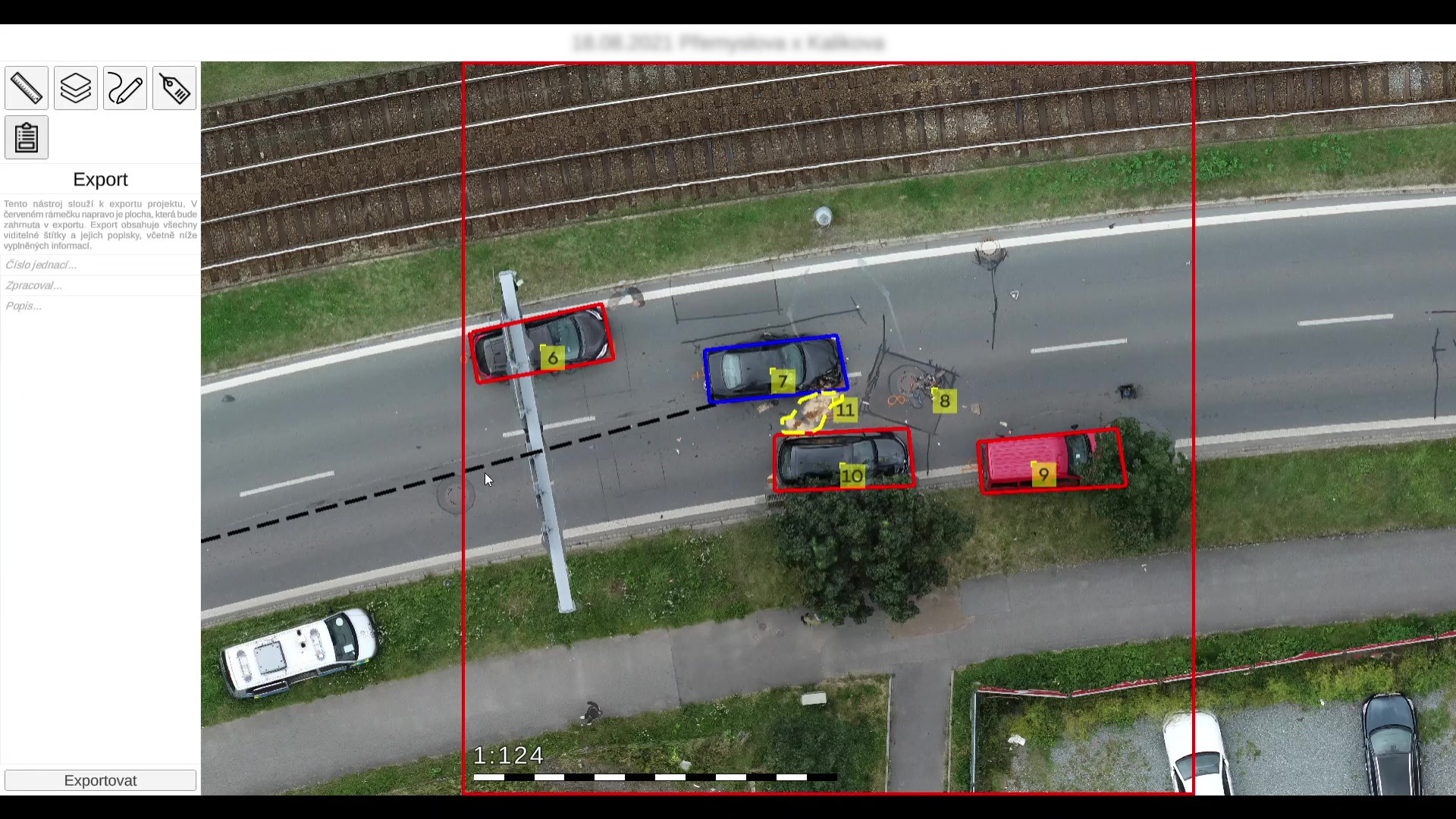
Crash Inspector can display even very demanding data simply and quickly, without loss of quality and with accuracy to the nearest centimetre. Each point or pixel has clear GPS and provides an accurate record of the accident scene not only for the needs of police officers, but also for forensic experts and other parties involved in the incident. In these records, police officers can measure distances, enter dimensions, describe and mark locations or tracks. The application can generate an accident report in the form and format that the police require.
Aim of the project:
- To provide assistance to the police when responding to serious traffic accidents.
- To create a record documenting the accident.
- To simplify the recording and handling options.
Results of the project:
- Development of a smart app called Crash Inspector.
- Creation of an accurate record of the crash and its use as an evidence,
- Further development of the app.
The officers’ experience showed how the application could be further developed to make their work more efficient. That’s why SIT Drones added so-called GIS layers to the app. These can be used to display the following information:
- Traffic signs – displays the exact location of the traffic sign, which makes it easier to determine who is at fault in an accident.
- Street markings – facilitates communication between the forces involved, a specific street can be named straight away.
In 2023, another enhancement to the Inspector came in the form of a point layer with precise targeting. These are fixed outdoor points, such as building corners or power line poles, and serve as starting position for measurements. To show these points in the area of an accident, SIT Drones have developed their own mobile app.
Of course, Crash Inspector includes a tool for drawing and editing in the footage (different types of highlighting, fonts, bullets, etc.). Police officers can mark tracks, braking paths and other necessary information in the image. All this is used to describe the event in more detail. The Crash Inspector record is provided with a scale for the area and the signature of the person who created it. This will also facilitate follow-up communication between those involved further in the investigation.
More information about the Crash Inspector app is available on the SIT Drones website.
-
assistance of the Police in serious accidents
-
smart app Crash Inspector
-
creating a very accurate record